
Unified Competence Framework Team

The Unified Competence Framework – PART 1
Unified competence framework developed by the Geo-Academy – The European sustainability competence framework (GreenComp)
Free
The Unified Competence Framework – PART 2
Unified competence framework developed by the Geo-Academy – Digital Competence Framework for Citizens (DigiComp)
Free
The Unified Competence Framework – PART 3
Unified competence framework developed by the Geo-Academy – Spatial Citizenship and Spatial Skills
Free
The Unified Competence Framework – PART 4
Unified competence framework developed by the Geo-Academy – The GEO-Academy Unified Competence Framework (UCF)
Free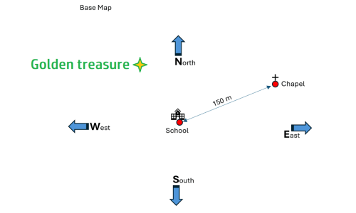
A plan for the primary level
The course presents a three-unit teaching sequence that engages students in hands-on activities to explore data acquisition, reference systems, and map layering. In the first unit, students use pedometers to measure their steps and calculate the average stride length by experimenting with different data collection methods, introducing them to concepts like mean value and unit conversion. The second unit focuses on spatial reference systems, where students measure the distance between their school and a nearby building, then create a base map marking key locations, distances, and compass directions. Building on this, the third unit has students add their home locations to the base map, layering individual data to create a collective city map that visualizes spatial relationships. Through these activities, students develop mathematical and geographical skills, learning to collect, analyze, and represent data in a meaningful way.
Free