Questioning and Creating Hypotheses About Spatial Representation
After the initial discussion about maps and orientation, students will likely begin to wonder how maps are created, interpreted, and used to solve spatial problems. Guide them through reflective questions that encourage curiosity and observation:
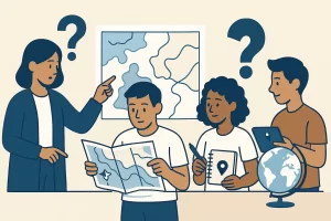
Questioning and Creating Hypotheses About Spatial Representation.
Illustration of students and a teacher collaboratively examining spatial information using maps, a globe,
and digital tools. The scene highlights curiosity, interpretation, and the development of hypotheses about
how maps represent space and how spatial data can be analyzed.Credits: Custom educational illustration created for the course
Exploring Spatial Skills and Map Literacy: A Cartography & GIS Peddy Paper Adventure, generated by an AI model..
How can a two-dimensional map represent our three-dimensional world?
What kind of information can we extract from a map besides location?
How accurate are our mental maps compared to real ones?
Encourage students to think about how people use maps in different contexts — from hikers finding trails to scientists studying deforestation or urban planners designing sustainable cities. Discuss that every map is a form of storytelling shaped by decisions about scale, symbols, and perspective. These discussions should help students realize that spatial thinking is both a scientific and creative process, requiring reasoning, estimation, and interpretation.
To deepen engagement, organize students into small groups and ask them to explore their local environment — the school grounds, nearby streets, or a public park — imagining how they would represent it on a map. Before any field activity, each group should discuss and record their assumptions:
– Which landmarks will be easiest to locate or identify?
– Will the map be more useful if we focus on distance, direction, or recognizable features?
– How can we use digital tools like GPS to validate our perception of space?
Students can then develop one or more research questions and hypotheses to guide their Peddy Paper challenge. Examples include:
– “If we rely only on a printed map, we may take longer to find certain locations than when using a digital map.”
– “Students with better mental maps of the school will make fewer navigation errors.”
– “Using GIS tools will make it easier to identify relationships between land use and geographic features.”
Encourage them to formulate their hypotheses clearly and record them in their inquiry journals. Each hypothesis should be testable during the outdoor exploration and data collection phase. Students can also sketch simple preliminary maps or mark potential routes and landmarks.
This stage helps students transition from observing maps to thinking like cartographers — questioning how information is represented, what spatial relationships matter, and how technology can enhance accuracy. It also strengthens their scientific reasoning, as they begin to predict outcomes and define strategies for validating their assumptions once the Peddy Paper begins.