Introduction to Maps, Spatial Thinking, and Orientation
In this activity, students will embark on a Cartography and GIS “Peddy Paper” Adventure, a playful outdoor investigation where they use maps, spatial clues, and GPS-enabled devices to locate and analyze points of interest. Through exploration, they will learn to decode map symbols, apply orientation strategies, collect spatial data, and construct their own digital or paper maps. The goal is to enhance their spatial awareness, critical observation, and teamwork, while fostering appreciation for how geospatial information supports decision-making—from navigating a schoolyard to understanding global sustainability challenges.
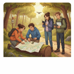
Cartography & GIS Peddy Paper Adventure.
Illustration of a mixed group of students working outdoors with paper maps,
compasses and GPS-enabled devices, following spatial clues to locate checkpoints
and record observations. The scene highlights teamwork, orientation strategies
and the use of geospatial information for decision-making.
Credits: Custom educational illustration created for the course
Exploring Spatial Skills and Map Literacy: A Cartography & GIS Peddy Paper Adventure, generated by an AI model..
Engage your students with the problem through simple introductory activities:
- Begin by asking: “How do you find your way when you’re in an unfamiliar place?” Then introduce different kinds of maps—topographic, thematic, digital—and invite students to explore interactive resources like Google Earth or OpenStreetMap. Let them compare how the same area appears across these tools and discuss how symbols, scales, and perspectives change what we see.
- Encourage students to experiment with basic orientation techniques: using a compass app, reading coordinates, or identifying cardinal directions based on the Sun’s position. For inspiration, they can access “Map Skills for Students” from National Geographic Education which introduces the main components of map reading and spatial reasoning.
- Challenge them to connect maps with their daily experience. Ask: “If you had to draw a map of your journey to school, what features would you include?” They can sketch the route from memory, noting landmarks, paths, and distances, and then compare it with the digital version on Google Maps. Discuss what is gained or lost when representing reality on paper or on screen, and how every map involves interpretation and choices