Experiment: Cartography & GIS Peddy Paper Adventure
To test their hypotheses, students will participate in a Cartography and GIS Peddy Paper Adventure, applying their spatial reasoning, navigation, and mapping skills in a real-world context. This stage combines physical exploration with geospatial analysis, enabling students to experience how cartography and GIS transform observations into data that can be represented and interpreted.
Students will receive a printed or digital base map of the selected area—such as the schoolyard, nearby park, or local neighborhood—prepared in advance by the teacher using tools like Google My Maps, ArcGIS Online, or QGIS. The map will include a series of checkpoints or clues representing locations that students must find using spatial hints (e.g., “Find the area shaded in green near the eastern gate” or “Locate the building marked with a square symbol”).
Experiment: Cartography & GIS Peddy Paper Adventure.
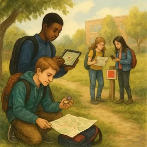
Illustration of students navigating a real-world environment using maps, compasses, GPS-enabled devices,
and spatial clues to locate checkpoints and collect geospatial observations. The scene highlights the
integration of fieldwork, orientation strategies, and georeferenced data collection.
Credits: Custom educational illustration created for the course
Exploring Spatial Skills and Map Literacy: A Cartography & GIS Peddy Paper Adventure, generated by an AI model..
As they navigate the route, students will:
- Use orientation tools such as compasses, smartphones, or GPS-enabled apps (e.g., Google Maps, Geo Tracker, or ArcGIS Field Maps) to find coordinates and verify their position.
- Collect spatial data at each checkpoint, including GPS coordinates, photos, sketches, and short notes describing land use, vegetation, or infrastructure.
- Apply map-reading skills to interpret symbols, distances, and scales, adjusting their navigation when necessary.
- Record their route using mobile devices or printed maps, marking discovered points of interest, obstacles, and orientation mistakes.
Data should be collected under varying conditions—different types of terrain, levels of human activity, or times of day—to help students reflect on how context affects orientation and perception. Environmental conditions (e.g., weather, visibility, or noise) should also be noted in the field notebook, since they influence the accuracy of spatial observations.
Additionally, for comparison, students can analyze the difference between mental maps (drawn from memory) and measured maps (produced with digital or georeferenced tools). They can discuss which features were easiest to identify, what elements were missing or distorted, and how technology improves or limits our spatial awareness.
After completing the fieldwork, students will return to the classroom to analyze their findings. They can overlay their collected points on a digital map using GIS software or online mapping platforms. Encourage them to reflect on:
– How accurate were their initial hypotheses?
– Did they find it easier to navigate with printed or digital maps?
– Were there unexpected challenges (e.g., scale errors, orientation confusion, GPS drift)?
All maps, notes, and digital data should be organized systematically for comparison and evaluation. Students should use their observations to revise their hypotheses, identifying which strategies were most effective in interpreting space. By connecting real exploration with digital analysis, they will gain a practical understanding of how cartography and GIS bridge physical geography and data science, turning movement, perception, and location into meaningful spatial knowledge.