GIS into the curriculum
Introduction
Geographic Information Systems (GIS) can be used to support learning outcomes across different subjects and levels of education, from elementary to higher education. Integrating GIS into the curriculum brings powerful opportunities for innovative, inquiry-, project- and challenge-based learning. By allowing learners to engage with real-world spatial data, GIS foster critical thinking, problem-solving, and collaboration across disciplines. In particular, this integration:
- ✅ Supports Constructivist Learning
GIS enables dynamic representations of real-world issues, encouraging students to explore and analyze problems from multiple spatial perspectives. - ✅ Promotes Project-Based Learning
GIS-based projects help students investigate local or global challenges by collecting, analyzing, and visualizing geospatial data. - ✅ Develops Key 21st-Century Skills
Through GIS, students build digital literacy, spatial reasoning, and data interpretation skills essential for academic and career success. - ✅ Empowers Teachers and Students
Educators can co-create knowledge with students, using GIS to explore the questions: What’s where? How does it work? Why is it there? - ✅ Strengthens Civic Engagement
GIS connects classroom learning to community issues, inspiring students to take informed action on sustainability, planning, and social equity.
As GIS continue to prove its value from local schools to international education systems, integrating it into national curricula is not just beneficial—it is a forward-thinking investment in the future of learning. GIS in education can bring numerous advantages for both students and teachers, such as enhancing engagement and motivation, promoting critical thinking and problem-solving skills, developing green and digital literacy as well as citizenship skills, and preparing students for future careers and opportunities. GIS can make learning more enjoyable, interactive, and applicable, as students can use maps, multimedia, and web-based tools to explore their own interests. It can also challenge students to ask questions, collect data, interpret results, and communicate findings. As an increasing number of examples from the local to global scale indicate, GIS-based projects provide a broad range of benefits to teachers and students in primary and secondary schools [1]. With GIS-based projects, teachers are able to work with their students on a local problem or public issue by collecting, recording, and analyzing their own data to answer the questions of what’s where? how?, and why is it there?
Whether or not you have heard of geospatial technologies, chances are it impacts our life every day. It keeps many of the things we take for granted running, like public transport, electricity, water, global supply chains, and emergency services, among others. It goes by such names as GIS, geostatistics, spatial analytics, and location intelligence. It helps people make better decisions about everything from how a city should prepare for a hurricane to where a national coffee company should open their next store. The following video showcases examples of what GIS pros produce and how through GIS we explore real-world examples of how GIS is used across different contexts.
Overall, GIS education is crucial for fostering a geospatially literate society where decision-makers consider the “where”, “why” and “how” in their daily work. Given the complexity of global challenges like climate change, biodiversity loss, and urbanization, it is imperative that GIS be taught at all levels of education. With the right tools and approaches tailored to students’ needs and educational levels, GIS can equip the next generation to address these challenges effectively.
Why GIS education?
Geospatiatial technologies might be quite impressive and helpful, however, do they have an added value on educational practices? GIS have seen significant integration into both higher and secondary education, particularly across the USA and Europe. The adoption of GIS, mainly in secondary education, began in the 1990s and has since expanded worldwide, with numerous studies highlighting its potential as a valuable educational tool.
Nowdays, and expecially after 2000s, GIS is embedded in geography curricula and sometimes extends to other subjects such as mathematics, biology, and environmental science in various countries. This trend is evident in countries like China, the USA, Canada, Malaysia, Hong Kong, Taiwan, South Africa, Egypt, Nigeria, as well as in many European countries. Finland, for instance, started considering GIS for secondary education in 2003, and by 2008, Switzerland had launched a nationwide initiative to incorporate GIS into the curriculum. Other European countries, including Norway and Germany, followed suit, recognizing the importance of GIS in education and its role in addressing various learning challenges, such as the need for more engaging, interactive learning environments. In Poland, GIS is utilized in secondary schools for tasks such as processing and presenting geographic data, interpreting thematic maps, and analyzing spatial information [2].
The above-mentioned exemplary cases indicated that integrating GIS into teaching empowers students to develop strong critical thinking skills through data analysis. As a dynamic instructional tool, GIS encourages inquiry-based learning and problem-solving. It allows learners to visualize spatial patterns, connections, and relationships—supporting informed, evidence-based decision making. Plus, GIS is engaging and enjoyable to use! But, why does using GIS in education matter to teaching, learning, our educational system, and society at large? The following video discusses these important issues.
As the video shows, GIS is a powerful tool for analyzing information connected to location. It helps answer critical “where” questions across countless fields. For example: Where are protected UNESCO heritage sites located across Europe? Where did key historical events—such as the Battle of Waterloo or World War II movements—take place? Where are Europe’s most important geological formations, like the Dolomites or Icelandic volcanoes? Where are crops at risk due to climate change in Southern Spain, Greece or Central Europe? Where is deforestation occurring in Europe? Which way are wind patterns driving wildfires in Portugal or Greece? It can also answer cultural and personal questions: Where did famous authors like Shakespeare or Tolstoy live? Where do tourists who visit the Oktoberfest in Munich or La Tomatina in Spain come from? Where are your favorite hiking trails in the Alps, fishing spots in Scandinavia, or national parks in the Balkans? Where are Europe’s top football teams based? With GIS, the possibilities for exploring “where” are endless!
Overall, GIS enhances students’ access to STEM education (Science, Technology, Engineering, and Mathematics) and prepares them for meaningful careers. It also revives fieldwork by incorporating technology, making it more accessible and engaging for students. The growing popularity of GIS in schools can be attributed to advancements in technology. Web-based tools such as ArcGIS Online or MapMaker and web mapping applications like Story Maps and 3D scenes have significantly reduced technological barriers. These tools eliminate the need for high-end computer labs and allow educators and students to access GIS from any device, anywhere, at any time. Another key development is the inclusion of GIS in national and state educational content standards. This is crucial, as what is included in the standards is what gets tested and taught. The growing use of field apps like Survey123 or FieldMaps, SW Maps and MapPT allow educators and students to collect data in the field, providing opportunities for hands-on learning. GIS is also beneficial in the administrative side of education. Schools may use GIS for tasks such as determining attendance boundaries, optimizing bus routes, and planning new campus/school locations. In an era of budget constraints, GIS offers valuable tools for improving operational efficiency and resource management.
As a result, a variety of pre-built lesson plans and resources make it easier for educators to incorporate GIS into their curricula. We will explore numerous lesson plans and project-based activities within the next lessons. Thus, these resources, combined with the ability to create multimedia web mapping applications, provide effective tools for both teaching and assessing student learning.
Despite these advancements, challenges still exist in implementing GIS in education. One difficulty is the interdisciplinary nature of GIS, which spans areas like geography, mathematics, computer science, and more. This makes it hard to fit into one specific course. Other challenges incorporate the lack of teachers’ knowledge on how to use GIS platfroms and apps, as also, the lack of support and the connections with higher education both in terms of training opportunities and in terms of collaboration in school projects. The figure below visually represents the possibilities and constraints of using GIS in K–12 education, as reported by in the article “Opportunities and Constraints in the Use of GIS in Secondary Education” published in the European Journal of Geography [3]. Let’s break down the analysis based on the article’s findings on the possibilities and constraints of GIS in K-12 education:
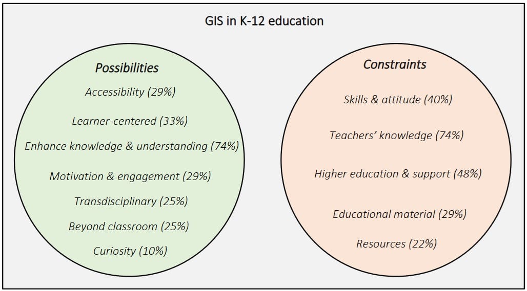
✅ Possibilities (Opportunities for Using GIS in K–12)
These reflect the benefits and pedagogical potential of GIS as perceived by educators and literature. Consequenlty, GIS incorporate:
- Enhance knowledge & understanding (74%)
This is the most frequently cited opportunity. It shows that GIS is recognized for its strong impact on conceptual learning, spatial awareness, and geographic (or spatial) thinking. - Learner-centered (33%), Motivation & engagement (29%), Accessibility (29%)
These percentages indicate GIS is seen as a way to create active learning environments, by connecting formal, non-formal and informal education, where students are more engaged and can access rich spatial data and tools easily. - Transdisciplinary (25%) and Beyond classroom (25%)
These reflect GIS’s interdisciplinary nature, which allows integration across different school subjects (science, history, environment, etc.) and encourages real-world, project-based learning. - Curiosity (10%)
Although less cited, GIS stimulates students’ natural interest in exploring their surroundings and their creativity, supporting inquiry-based learning approaches.
⚠️ Constraints (Barriers to GIS Integration)
These highlight the systemic, pedagogical, and logistical challenges faced in integrating GIS into secondary (and primary) education:
- Teachers’ knowledge (74%)
A key constraint—matching the top opportunity—is the lack of sufficient GIS knowledge or confidence among teachers. This often results in underutilization of the technology. - Higher education & support (48%)
Indicates a lack of support structures and training pathways for teachers in GIS through universities or professional development courses. - Skills & attitude (40%)
This may refer to both students’ and teachers’ digital competences and openness to adopt new tools and cutting-edge technologies. - Educational material (29%) and Resources (22%)
These concern the availability of quality GIS curriculum materials (i.e. lesson plans, teacher handbooks), software, and hardware in schools.
In light of the aforementioned challenges and constraints, the GEO-Academy project (https://geoacademy.eu/) plays a key role in addressing several long-standing barriers that have limited the use of GIS in classroom practices. These include the lack of sufficient (and unified) knowledge and skills among teachers, negative attitudes toward adopting new technologies, and the absence of accessible tools and clear connections between GIS and real-world applications.
1 Comment
Submit a Comment
You must be logged in to post a comment.
1. What is the difference between GIS and geoinformatics, geomaths, and geostatistics?
2. What do we mean by GIS, as an information system and information science?